Image segmentation on satellite images
Objective
The primary objective of this project is to develop a reliable system for segmenting satellite images into three categories: Agriculture Lands, Water Bodies, and Urban Buildings, using YOLOv8 for object detection. The system will process satellite images, detect the regions corresponding to these categories, and classify them accurately
Abstract
ABSTRACT:
The project focuses on image segmentation applied to satellite images, utilizing YOLOv8 for detecting and classifying regions in the images into three distinct categories: Agriculture Lands, Water Bodies, and Urban Buildings. The satellite images are preprocessed and segmented to help in understanding land use and management on a large scale. This segmentation can be vital for urban planning, resource management, and environmental monitoring. The backend of the system is built with Flask, while the front end is designed using HTML, CSS, and JavaScript for a user-friendly interface. The system offers efficient, real-time processing for classifying and segmenting satellite imagery, providing valuable insights for various sectors like agriculture, urban development, and environmental protection.
Keywords: YOLOv8, Flask framework, real-time classification.
NOTE: Without the concern of our team, please don't submit to the college. This Abstract varies based on student requirements.
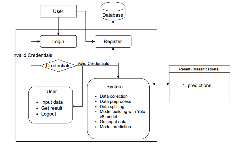
Block Diagram
Specifications
Requirements
Hardware Requirements
Operating system : Windows 7 or 7+
RAM : 8 GB
Hard disc or SSD : More than 500 GB
Processor : Intel 3rd generation or high or Ryzen with 8 GB Ram
Software Requirements:
Software’s : Python 3.10 or high version
IDE : Visual Studio Code.
Framework : Flask
IDE/Workbench : PyCharmTechnology : Python 3.6+
Server Deployment : Xampp Server
Database : MySQL


Related Projects
 Paper Publishing

Request Call Back
Would you like to receive a free callback now?
Choose the best time for callback:
Leave your message and we will contact you as soon as possible

6-2-85/B, Old Maternity Hospital Road, Thyagaraja Nagar, Tirupati, Andhra Pradesh – 517501
+91 9030333433
+91 9393939065
0877-2261612

Disclaimer - Takeoff Edu Group Projects are not associated or affiliated with IEEE in any way. The IEEE Projects mentioned here are mentioned in the context of student projects, whose ideas are derived from IEEE publications, not projects of or by IEEE.