Disaster Management and Mapping Using Satellite Images
Objective
Develop an automated system using CNN and ResNet for classifying natural disaster damage in satellite images, aiding disaster response.
Abstract
Disaster Management and Mapping Using Satellite Images
ABSTRACT:
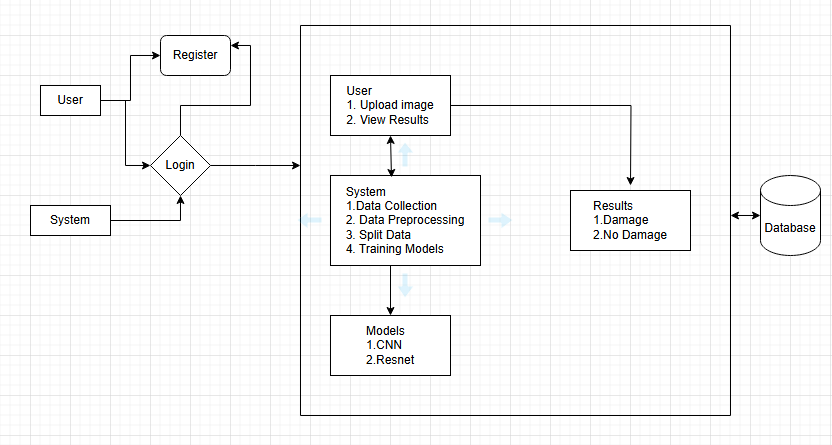
Disaster detection using satellite imagery has become an essential tool in disaster management, providing valuable insights into affected areas in real-time. This project focuses on the development of a deep learning-based system to classify regions into two categories: Damage and No Damage in the aftermath of natural disasters. Utilizing convolutional neural networks (CNN) and ResNet architectures, the system is designed to automatically analyze satellite images and identify areas affected by disasters, such as floods, earthquakes, and hurricanes. The backend of the system is built using Python, which handles the data processing, model training, and prediction tasks. The front-end, created with HTML, CSS, and JavaScript, provides an intuitive interface for users to upload satellite images and view the classification results. This framework allows for rapid response and effective decision-making during disaster management, aiding in resource allocation and relief efforts.
Keywords:
Disaster Detection, Satellite Images, Deep Learning, Convolutional Neural
Networks (CNN), ResNet.
NOTE: Without the concern of our team, please don't submit to the college. This Abstract varies based on student requirements.
Block Diagram
Specifications
· Processor - I3/Intel Processor
· RAM - 4GB (min)· Hard Disk - 160GB
· Key Board - Standard Windows Keyboard
· Mouse - Two or Three Button Mouse
· Monitor - SVGA
2. S/W System Configuration:-
· Operating System : Windows 7/8/10
· Application Server : Python
· Front End : HTML, CSS, Bootstrap
· Database : SQLYog
- Server : Xampp


Related Projects
 Paper Publishing

Request Call Back
Would you like to receive a free callback now?
Choose the best time for callback:
Leave your message and we will contact you as soon as possible

6-2-85/B, Old Maternity Hospital Road, Thyagaraja Nagar, Tirupati, Andhra Pradesh – 517501
+91 9030333433
+91 9393939065
0877-2261612

Disclaimer - Takeoff Edu Group Projects are not associated or affiliated with IEEE in any way. The IEEE Projects mentioned here are mentioned in the context of student projects, whose ideas are derived from IEEE publications, not projects of or by IEEE.