Classifying Remote Sensing Scenes with Vision Transformers and Convolutional Neural Networks
Objective
The growing need for land use and land cover classification is driven by the increasing demand for environmental monitoring and urban planning. Remote sensing technologies provide valuable information about the Earth's surface, aiding in natural resource management, disaster monitoring, and urbanization studies. However, manually classifying large sets of remote sensing images can be a time-consuming and error-prone process. The motivation behind this project is to automate this classification process using deep learning models, which can handle large datasets more efficiently and accurately than traditional methods. By utilizing CNNs, MobileNet, DenseNet, and ViT models, this project aims to create a system that can classify various scene types in remote sensing images with high precision. This system not only enhances the speed and accuracy of classification tasks but also contributes to research and development in environmental monitoring.
Abstract
Remote sensing image classification plays a crucial role in mapping and understanding various land types. This project focuses on scene classification using deep learning models. The dataset used for this study contains aerial images from different scenes such as urban areas, forests, water bodies, and agricultural zones. The proposed system uses Convolutional Neural Networks (CNN), MobileNet, DenseNet, and Vision Transformer (ViT) models to extract features and classify scenes. These models are chosen for their ability to process and analyze visual data efficiently, even in complex and large datasets. The project’s objective is to improve the accuracy and efficiency of remote sensing scene classification using these advanced models. The system is developed with a user-friendly web interface where users can upload images and receive scene classifications. The backend uses Flask, while the frontend is built using HTML, CSS, and JavaScript. The system can be deployed and used for automated classification tasks across different applications.
Keywords: Remote sensing, image classification, deep learning, CNN, MobileNet, DenseNet, ViT, feature extraction, aerial images, scene types.
NOTE: Without the concern of our team, please don't submit to the college. This Abstract varies based on student requirements.
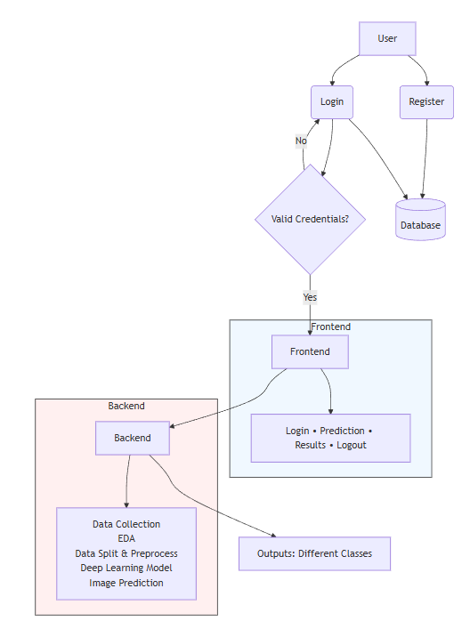
Block Diagram
Specifications
Hardware Requirements
Processor - I3/Intel Processor
Hard Disk - 160GB
Key Board - Standard Windows Keyboard
Mouse - Two or Three Button Mouse
Monitor - SVGA
RAM - 8GB
Software Requirements:
Operating System : Windows 7/8/10
Server side Script : HTML, CSS, Bootstrap & JS
Programming Language : Python
Libraries : Flask/Django, Pandas, Mysql.connector, Os, Smtplib, Numpy
IDE/Workbench : PyCharm
Technology : Python 3.6+
Server Deployment : Xampp Server
Database : MySQL

Demo Video


Request for Video
Related Projects
 Paper Publishing
Request Call Back
Would you like to receive a free callback now?
Choose the best time for callback:
Leave your message and we will contact you as soon as possible

6-2-85/B, Old Maternity Hospital Road, Thyagaraja Nagar, Tirupati, Andhra Pradesh – 517501
+91 9030333433
+91 9393939065
0877-2261612

Disclaimer - Takeoff Edu Group Projects are not associated or affiliated with IEEE in any way. The IEEE Projects mentioned here are mentioned in the context of student projects, whose ideas are derived from IEEE publications, not projects of or by IEEE.