Wildfire Risk Assessment and Detection for Remote Terrain
Objective
The objective of the Wildfire Risk Assessment and Detection for Remote Terrain is to monitor environmental conditions using IoT and AI to predict and detect wildfire risks in real time. The system analyzes temperature, humidity, wind patterns, and smoke levels to provide early warnings and improve disaster response
Abstract
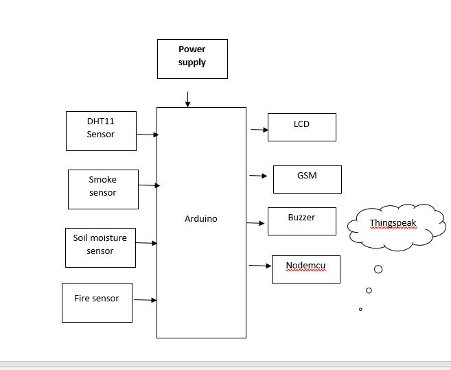
The Wildfire Risk Assessment and Detection for Remote Terrain project presents an intelligent monitoring system designed to detect and predict wildfire hazards using real-time environmental data. The system employs sensors such as the DHT11 for measuring temperature and humidity, the MQ-2 sensor for detecting smoke and combustible gases, and a soil moisture sensor to assess ground dryness, which is a critical factor in fire risk prediction. A microcontroller like the Arduino Uno or ESP32 collects and processes the sensor data to identify abnormal conditions such as high temperature, low humidity, presence of smoke, and low soil moisture levels. When these parameters exceed predefined thresholds, the system generates alerts through a buzzer and sends notifications via a GSM module, while also uploading data to cloud platforms like ThingSpeak for remote monitoring and analysis. This integrated approach enables early warning, improves response time, and reduces the risk of large-scale wildfire damage, making the system suitable for forest surveillance and remote terrain safety applications.
NOTE: Without the concern of our team, please don't submit to the college. This Abstract varies based on student requirements.
Block Diagram
Specifications
Hardware requirements:
- Arduino
- LCD
- Power supply
- 12v 1A Adapter
- Smoke Sensor
- Fire Sensor
- DHT11
- Soil moisture sensor
- GSM
- Buzzer
- Nodemcu
Software requirements:
- Arduino IDE
- Embedded C
Learning Outcomes
- Learning outcomes:
- Arduino Pin diagram and Architecture
- How to install Arduino IDE Software
- Installation of Python IDLE
- Setting up and Installation procedures for Arduino IDE
- Introduction to Arduino IDE
- Commands in Embedded C
- How to install Libraries?
- Basic coding in Embedded C
- Working of Dallas temp
- Working of TDS Sensor
- How to interface Turbidity with Arduino
- How to interface Ph scale with Arduino?
- Working of LCD
- How to interface LCD with Arduino?
- About Project Development Life Cycle:
- Planning and Requirement Gathering (software’s, Tools, Hardware components, etc.,)
- Schematic preparation
- Code development and debugging
- Hardware development and debugging
- Development of the Project and Output testing
- Practical exposure to:
- Hardware and software tools.
- Solution providing for real time problems.
- Working with team/ individual.
- Work on Creative ideas.
- Project development Skills
- Problem analyzing skills
- Problem solving skills
- Creativity and imaginary skills
- Programming skills
- Deployment
- Testing skills
- Debugging skills
- Project presentation skills
- Thesis writing skills


 Paper Publishing

Request Call Back
Would you like to receive a free callback now?
Choose the best time for callback:
Leave your message and we will contact you as soon as possible

6-2-85/B, Old Maternity Hospital Road, Thyagaraja Nagar, Tirupati, Andhra Pradesh – 517501
+91 9030333433
+91 9393939065
0877-2261612

Disclaimer - Takeoff Edu Group Projects are not associated or affiliated with IEEE in any way. The IEEE Projects mentioned here are mentioned in the context of student projects, whose ideas are derived from IEEE publications, not projects of or by IEEE.