Satellite Image Classification Method Using CNN
Objective
The main objective of this project is to classify satellite images among a set of 3 different classes.
Abstract
Deep learning-based CNN methods have been used for the classification of satellite images among a set of 3 different classes. This work does not only classify the satellite image class this work is also capable of classifying 3 different class however to identify the features of those other classes like the cats, dog. is also simple because these other classes have some exclusive features which can be simply to differentiate hence easy classification. In the case of the satellite image, the major issue is that different satellite images may have different features that make satellite image classification hard. Another issue is that safelight images are normally noise corrupted. The noise patterns of the wireless image are estimated using CNN model. The method used in this work is the Satellite image correct recognition obtain is 75.94%.
Keywords: CNN, Deep Learning, Pre-processing, Image classification, .
NOTE: Without the concern of our team, please don't submit to the college. This Abstract varies based on student requirements.
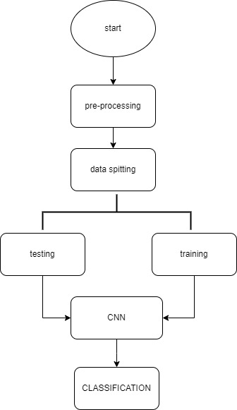
Block Diagram
Specifications
H/W Specifications:
- Processor:
I3/Intel Processor
- RAM: 8GB (min)
- Hard Disk: 160 GB
S/W Specifications:
- Operating System : Windows 7/8/10
- Server-side Script: HTML, CSS & JS.
- IDE : PyCharm
- Libraries Used :NumPy, IO, OS, TensorFlow, Keras.
- Technology:Python 3.6+.


 Paper Publishing

Request Call Back
Would you like to receive a free callback now?
Choose the best time for callback:
Leave your message and we will contact you as soon as possible

6-2-85/B, Old Maternity Hospital Road, Thyagaraja Nagar, Tirupati, Andhra Pradesh – 517501
+91 9030333433
+91 9393939065
0877-2261612

Disclaimer - Takeoff Edu Group Projects are not associated or affiliated with IEEE in any way. The IEEE Projects mentioned here are mentioned in the context of student projects, whose ideas are derived from IEEE publications, not projects of or by IEEE.