Satellite Based Forest Stand Detection Using Artificial Intelligence
Objective
The objective of this project is to develop an artificial intelligence-based system for satellite-based forest stand detection. The project aims to accurately detect and classify forest stands into 44 distinct categories using high-resolution satellite images. By utilizing deep learning techniques such as ResNet-50, CNN + Wavelet Attention, and GradCam++, the system will enhance the precision of forest classification. The goal is to create a robust, scalable, and automated system that can classify forest stands in real-time, aiding forest management, conservation efforts, and sustainable land-use practices. This system will provide valuable insights for monitoring biodiversity, assessing deforestation rates, and improving forest resource management.
Abstract
Satellite-based forest stand detection plays a crucial role in monitoring and managing forest ecosystems, especially with the increasing challenges posed by deforestation and climate change. This project aims to enhance the detection of forest stands using satellite imagery and artificial intelligence. The system leverages a multi-class image classification approach, utilizing deep learning techniques to classify satellite images into 44 distinct classes of forest stands. Three primary algorithms have been implemented: ResNet-50, a powerful convolutional neural network known for its deep architecture; CNN + Wavelet Attention, which integrates the attention mechanism with wavelet transforms for improved feature extraction; and GradCam++, a technique that enhances interpretability by providing visual explanations for model decisions. These algorithms are applied to analyze high-resolution satellite images and classify them into various forest stand categories, improving the accuracy and reliability of forest monitoring. The project employs Python and deep learning frameworks such as Keras and TensorFlow for model implementation and evaluation. The results show that the combination of these deep learning models offers significant potential for satellite-based forest stand detection, supporting sustainable forest management and conservation efforts.
Keywords: Satellite-based detection, Forest Stand Classification, Deep Learning, ResNet-50, CNN + Wavelet Attention, GradCam++, Multi-class Classification, Artificial Intelligence, Forest Monitoring, Sustainable Forest Management, Python, TensorFlow, Keras.
NOTE: Without the concern of our team, please don't submit to the college. This Abstract varies based on student requirements.
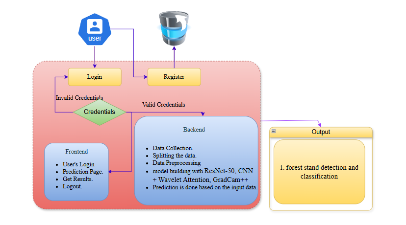
Block Diagram
Specifications
SOFTWARE REQUIREMENS
Operating System : Windows 7/8/10
Server side Script : html,css,js
Programming Language : Python
Libraries : Django, Pandas, Torch, Keras, Sklearn,Numpy , Seaborn
IDE/Workbench : VSCode
Server Deployment : Xampp Server
Database : SQLite
HARDWARE REQUIREMENTS
Processor - I3/Intel Processor
RAM - 8GB (min)
Hard Disk - 128 GB
Key Board - Standard Windows Keyboard
Mouse - Two or Three Button Mouse
Monitor - Any

Demo Video


Request for Video
 Paper Publishing
Request Call Back
Would you like to receive a free callback now?
Choose the best time for callback:
Leave your message and we will contact you as soon as possible

6-2-85/B, Old Maternity Hospital Road, Thyagaraja Nagar, Tirupati, Andhra Pradesh – 517501
+91 9030333433
+91 9393939065
0877-2261612

Disclaimer - Takeoff Edu Group Projects are not associated or affiliated with IEEE in any way. The IEEE Projects mentioned here are mentioned in the context of student projects, whose ideas are derived from IEEE publications, not projects of or by IEEE.