Satellite-Based Forest Stand Detection Using Artificial Intelligence
Objective
To detect and classify forest stands using satellite imagery. AI helps automate and scale forest monitoring.
Abstract
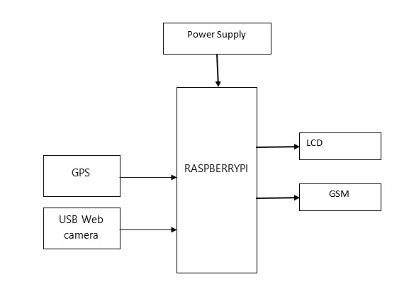
Forest monitoring plays a vital role in environmental conservation, biodiversity management, and sustainable forestry practices. This project presents a satellite-based forest stand detection system using Artificial Intelligence with Raspberry Pi as the main controller. The system integrates a USB web camera, LCD display, GPS module, GSM module, and buzzer for intelligent forest monitoring and alert generation. Satellite imagery and AI-based image analysis techniques are used to identify forest stands, vegetation density, and changes in forest cover. The USB web camera provides local image acquisition for verification and monitoring purposes. The Raspberry Pi processes the collected images using AI algorithms to detect forest regions and identify abnormal conditions such as deforestation or degradation. The GPS module records the geographical location of detected events, while the GSM module sends alert messages to authorized personnel. The LCD displays monitoring information and system status, and the buzzer provides immediate local alerts whenever significant changes are detected. The proposed system offers a low-cost, intelligent, and real-time solution for forest monitoring, supporting environmental protection and sustainable resource management.
Keywords: Raspberry Pi, Artificial Intelligence, Forest Stand Detection, Satellite Imagery, GPS, GSM, Environmental Monitoring, Forest Management.
NOTE: Without the concern of our team, please don't submit to the college. This Abstract varies based on student requirements.
Block Diagram
Specifications
Hardware components:
- Raspberry pi
- LCD
- SD Card
- USB Web camera
- Gsm
- GPS
- Buzzer
- connectors-10
Software requirements:
- Arduino IDE
- Embedded C
Learning Outcomes
- Arduino pin diagram and architecture
- How to install Arduino UNO / setup software
- Setting up and installation procedure for Arduino UNO
- Introduction to Arduino UNO environment / development setup Basic programming in Arduino UNO (Embedded C)
- Basics of Embedded programming using Arduino UNO
- Basics of IoT platforms
- Working of power supply
- About Project Development Life Cycle:
- Planning and Requirement Gathering (software, tools, hardware components, etc.)
- Schematic preparation
- Code development and debugging
- Hardware development and debugging
- Development of the project and output testing
- Practical exposure to:
- Hardware and software tools
- Solution providing for real-time problems
- Working with team/individual
- Work on creative ideas
- Skills developed:
- Project development skills
- Problem analyzing skills
- Problem solving skills
- Creativity and imaginative skills
- Programming skills
- Deployment
- Testing skills
- Debugging skills
- Project presentation skills
- Thesis writing skills


 Paper Publishing

Request Call Back
Would you like to receive a free callback now?
Choose the best time for callback:
Leave your message and we will contact you as soon as possible

6-2-85/B, Old Maternity Hospital Road, Thyagaraja Nagar, Tirupati, Andhra Pradesh – 517501
+91 9030333433
+91 9393939065
0877-2261612

Disclaimer - Takeoff Edu Group Projects are not associated or affiliated with IEEE in any way. The IEEE Projects mentioned here are mentioned in the context of student projects, whose ideas are derived from IEEE publications, not projects of or by IEEE.