Predicting Urban Land Cover Using Classification A Machine Learning Approach
Objective
The project aims to develop an intelligent land cover classification system using machine learning techniques to support urban planners, environmentalists, and policymakers. It applies models such as Random Forest, XGBoost, and Stacking Ensemble to classify land into six categories—Commercial, Forest, Industrial, Residential, Vegetation, and Water—based on spectral and texture features like mean RGB values, standard deviation, texture, entropy, and NDVI. The system ensures accurate predictions through performance evaluation using metrics such as accuracy, precision, recall, and F1-score. A user-friendly web application built with Flask enables users to upload data and obtain predictions, while MySQL supports data management and scalability. Overall, the system provides data-driven insights to assist in sustainable land use planning and environmental monitoring.
Abstract
This project, UrbanLens, presents a robust machine learning framework for the automated classification of urban land cover using multispectral and texture features derived from satellite or aerial imagery. The system is designed to distinguish six critical land cover categories: Commercial, Forest, Industrial, Residential, Vegetation, and Water. The methodology involved a comprehensive pipeline including data preprocessing, feature scaling, and the application of SMOTE to address class imbalances.A comparative analysis of multiple powerful models was conducted, including ensemble learning algorithms—Random Forest (98.7% accuracy), XGBoost (98.9% accuracy), and a Stacking Classifier combining both with a Ridge meta-learner (98.9% accuracy)—along with a deep learning approach using a Multi-Layer Perceptron (MLP) model (99% accuracy), which demonstrated the highest predictive performance by effectively capturing complex non-linear relationships in the data.The models were trained on nine key features: mean and standard deviation of RGB bands, texture, entropy, and the Normalized Difference Vegetation Index (NDVI). Beyond model development, this project includes a functional framework for real-world application, offering actionable suggestions for each predicted class, such as identifying a "Residential" area for urban planning or a "Water" body for preservation. By automating land cover analysis with near 99% accuracy, UrbanLens provides urban planners, environmentalists, and policymakers with a powerful, accessible tool for monitoring urban sprawl, managing forest resources, and driving sustainable development. The inclusion of both ensemble and deep learning techniques highlights the transformative potential of advanced machine learning in geospatial intelligence.
Keywords: Machine Learning, Land Cover Classification, Remote Sensing, Urban Planning, Random Forest, XGBoost, Stacking Ensemble, NDVI, Spectral Analysis, Texture Analysis, SMOTE, Geospatial Intelligence, Environmental Monitoring, Sustainable Development, Predictive Analytics.
NOTE: Without the concern of our team, please don't submit to the college. This Abstract varies based on student requirements.
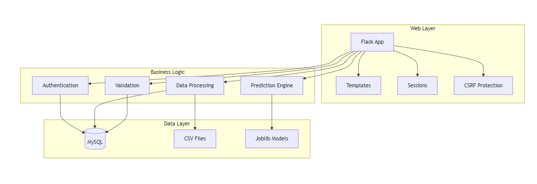
Block Diagram
Specifications
4.1 SOFTWARE REQUIREMENS
Operating System : Windows 7/8/10
Server side Script : HTML, CSS, Bootstrap & JS
Programming Language : Python
Libraries : Flask, Pandas, Sklearn, Numpy , Seaborn
IDE/Workbench : VSCODE
Server Deployment : Xampp Server
Database : MySQL
4.2 HARDWARE REQUIREMENTS
Processor - I3/Intel Processor
RAM - 8GB (min)
Hard Disk - 128 GB
Key Board - Standard Windows Keyboard
Mouse - Two or Three Button Mouse
Monitor - Any


Related Projects
 Paper Publishing

Request Call Back
Would you like to receive a free callback now?
Choose the best time for callback:
Leave your message and we will contact you as soon as possible

6-2-85/B, Old Maternity Hospital Road, Thyagaraja Nagar, Tirupati, Andhra Pradesh – 517501
+91 9030333433
+91 9393939065
0877-2261612

Disclaimer - Takeoff Edu Group Projects are not associated or affiliated with IEEE in any way. The IEEE Projects mentioned here are mentioned in the context of student projects, whose ideas are derived from IEEE publications, not projects of or by IEEE.