IOT based GPS Tracking and Visualization in MATLAB
Objective
This project deals with the visualization of a graphical area of land using peak server and helps to find the vegetation in that area.
Abstract
This project deals the concept of IoT based GPS tracking and visualization. Increasing commercial use of the Global Positioning System will soon make it possible to locate anything, anywhere, anytime. The Global Positioning System can provide extremely accurate location information for mobile objects and people which is far superior to earlier tracking techniques.
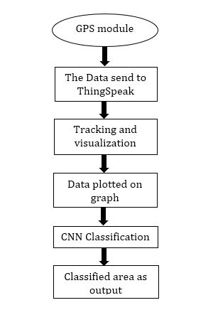
A GPS stands for Global Positioning System which is a worldwide radio-navigation system. This network consists of a range of satellites that uses microwave signals to transmit the data which will be received by the GPS receiver module. In order to track the location of phone, a GPS module is inserted into the mobile and communicate with satellite. The data is plotted by considering the data from GPS receiver module and Thing Speak. By using CNN classifier we classify the area.
Keywords: Thing Speak, Global Positioning System (GPS) receiver module, satellites.
NOTE: Without the concern of our team, please don't submit to the college. This Abstract varies based on student requirements.
Block Diagram
Specifications
Hardware & Software Requirements:
Software: Matlab 2018a or above
Hardware:
Operating Systems:
- Windows 10
- Windows 7 Service Pack 1
- Windows Server 2019
- Windows Server 2016
Processors:
Minimum: Any Intel or AMD x86-64 processor
Recommended: Any Intel or AMD x86-64 processor with four logical cores and AVX2 instruction set support
Disk:
Minimum: 2.9 GB of HDD space for MATLAB only, 5-8 GB for a typical installation
Recommended: An SSD is recommended a full installation of all Math Works products may take up to 29 GB of disk space.
RAM:
Minimum: 4 GB
Recommended: 8 GB
Learning Outcomes
- Introduction to Matlab
- What is EISPACK & LINPACK
- How to start with MATLAB
- About Matlab language
- Matlab coding skills
- About tools & libraries
- Application Program Interface in Matlab
- About Matlab desktop
- How to use Matlab editor to create M-Files
- Features of Matlab
- Basics on Matlab
- What is an Image/pixel?
- About image formats
- Introduction to Image Processing
- How digital image is formed
- Importing the image via image acquisition tools
- Analyzing and manipulation of image.
- Phases of image processing:
- Acquisition
- Image enhancement
- Image restoration
- Color image processing
- Image compression
- Morphological processing
- Segmentation etc.,
- About Artificial Intelligence (AI)
- About Machine Learning
- About Deep Learning
- About layers in AI (input, hidden and output layers)
- Building AI (ANN/CNN) architecture using Matlab
- We will able to know, what’s the term “Training” means in Artificial Intelligence
- About requirements that can influence the AI training process:
- Data
- Training data
- Validation data
- Testing data
- Hardware requirements to train network
- How to track and visualize the GPS using AI
- How to extend our work to another real time applications
- Project development Skills:
- Problem analyzing skills
- Problem solving skills
- Creativity and imaginary skills
- Programming skills
- Deployment
- Testing skills
- Debugging skills
- Project presentation skills
- Thesis writing skills


 Paper Publishing

Request Call Back
Would you like to receive a free callback now?
Choose the best time for callback:
Leave your message and we will contact you as soon as possible

6-2-85/B, Old Maternity Hospital Road, Thyagaraja Nagar, Tirupati, Andhra Pradesh – 517501
+91 9030333433
+91 9393939065
0877-2261612

Disclaimer - Takeoff Edu Group Projects are not associated or affiliated with IEEE in any way. The IEEE Projects mentioned here are mentioned in the context of student projects, whose ideas are derived from IEEE publications, not projects of or by IEEE.