Improving Marine Ecosystem Monitoring through Transfer Learning and Deep Multisensor Data Integration
Objective
This project develops a deep learning system to classify satellite images of coastal and aquatic areas into six categories: Beach, Island, Lake, River, Sea Ice, and Wetland. Models like CNN, ResNet50, EfficientNetB0, and VGG16 are used, with preprocessing and augmentation to improve accuracy. The system helps monitor and manage coastal environments efficiently and is deployed with a user-friendly interface.
Abstract
The primary aim of this project is to design and implement an image classification system for coastal and aquatic land cover using deep learning techniques. Coastal regions and aquatic environments are crucial for biodiversity, environmental health, and natural resources. This research focuses on utilizing various deep learning models, including Convolutional Neural Networks (CNN), ResNet50, EfficientNetB0, and VGG16, to classify satellite images of coastal and aquatic land cover into six categories: Beach, Island, Lake, River, Sea Ice, and Wetland. Data preprocessing techniques, including data augmentation, normalization, and resizing, are applied to enhance model performance and prevent overfitting. The models are trained using a dataset consisting of high-resolution satellite images. The accuracy of the models is evaluated using various performance metrics, including accuracy, precision, recall, F1-score, and confusion matrix. The results show that the models, particularly the pre-trained ResNet50, EfficientNetB0, and VGG16, perform well in classifying the images with high accuracy. The system is deployed using Flask, offering a user-friendly interface for image upload and classification. This tool provides a reliable method for monitoring and classifying coastal and aquatic environments, which can assist in environmental management, conservation efforts, and research. The project aims to present an effective and efficient deep learning-based solution for land cover classification, contributing to advancements in environmental studies.
Keywords: Image Classification, Deep Learning, Coastal Land Cover, Aquatic Environments, Convolutional Neural Networks, ResNet50, EfficientNetB0, VGG16, Satellite Imagery, Environmental Monitoring.
NOTE: Without the concern of our team, please don't submit to the college. This Abstract varies based on student requirements.
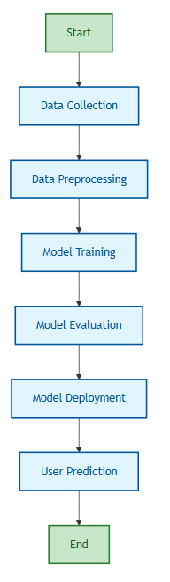
Block Diagram
Specifications
H/W CONFIGURATION:
Processor - I3/Intel Processor
Hard Disk - 160GB
Key Board - Standard Windows Keyboard
Mouse - Two or Three Button Mouse
Monitor - SVGA
RAM - 8GB
S/W CONFIGURATION:
• Operating System : Windows 7/8/10
• Server side Script : HTML, CSS, Bootstrap & JS
• Programming Language : Python
• Libraries : Flask, Pandas, MySQL. Connector, Scikit-Learn, pytorch
• IDE/Workbench : VS Code
• Technology : Python 3.8+
• Server Deployment : Xampp Server


 Paper Publishing

Request Call Back
Would you like to receive a free callback now?
Choose the best time for callback:
Leave your message and we will contact you as soon as possible

6-2-85/B, Old Maternity Hospital Road, Thyagaraja Nagar, Tirupati, Andhra Pradesh – 517501
+91 9030333433
+91 9393939065
0877-2261612

Disclaimer - Takeoff Edu Group Projects are not associated or affiliated with IEEE in any way. The IEEE Projects mentioned here are mentioned in the context of student projects, whose ideas are derived from IEEE publications, not projects of or by IEEE.