Geographical Information System (GIS)
Objective
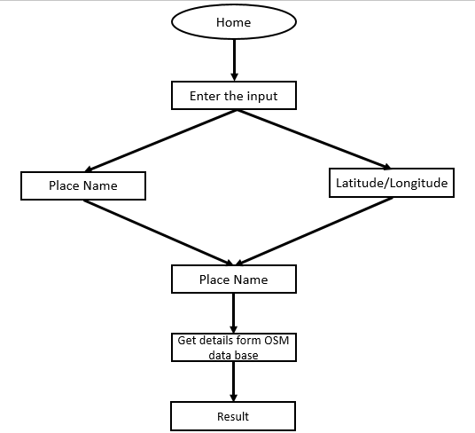
The main objective of this implementation is to fetch the details of the geographical information by entering the location name.
Abstract
GIS technologies have been applied to diverse fields to assist people in analysing various types of geospatial data and dealing with complex situations. In the field of agriculture investment project management, as you know they are closely related with location, managers are increasingly aware of the important function of location information and such GIS location analysis technology to enhance management capacity. This paper shows a case about the application of GIS in Zhejiang provincial standard farmland quality management. It proposed several methods of location match analysis for the business checking, developed two interrelated system for different needs, `Map Draw Tool' desktop GIS app and Web GIS-based app. Its success running in recent three years demonstrated that the proposed system can effectively prevent inaccurate and duplicate project applying phenomenon, and conducive to accepting social supervision by publishing them online with web map.
People have been using maps since immemorial times. However, since the end of the XX century when GISs became implemented into the processes of maps production, new types of spatial data models began to appear in addition to the usual cartographic imagery. Number of these models tends to grow, and consequently new terminology, classifications and standards are needed. Such terms as GIS-based mapping, geomatics and geoiconics have taken their place in the terminology of modern cartography. The article highlights the problems and trends of GIS-based mapping. Suggested several example projects which were done with the participation of the article authors, representing the integration of traditional and modern methods. The first example: the creation of maps with the original system of symbols, applying a design approach to the creation of map works. The work on the creation of the Atlas of Orthodoxy is a vivid example of this trend. The second example: the maps “support” the research and visualize or reflect the results of geoinformation analysis. Over the past ten years, active work has been carried out to support hydrological projects in the Arctic and Antarctic, as well as archaeological research in the Smolensk region and in the region of the Middle Yenisei. In such projects prevail, of course, mostly geoinformational approaches. The third example: the creation of maps using photographs and / or on the basis of aerial and satellite images. In archaeological studies conducted jointly with the Institute of the History of Material Culture of the Russian Academy of Sciences in the region of the Middle Yenisei; this kind of data is the most informative.
NOTE: Without the concern of our team, please don't submit to the college. This Abstract varies based on student requirements.
Block Diagram
Specifications
Hardware:
- Operating system: Windows 7 or 7+
- RAM: 8 GB
- Hard disc or SSD: More than 500 GB
- Processor : Intel 3rd generation or high or Ryzen with 8 GB Ram
Software:
- Software’s: Python 3.6 or high version
- IDE: PyCharm.
- Framework: Flask
Learning Outcomes
· Practical exposure to
· Hardware and software tools
· Solution providing for real time problems
· Working with team/individual
· Work on creative ideas
· Testing techniques
· Error correction mechanisms
· What type of technology versions is used?
· Working of Tensor Flow
· Implementation of Deep Learning techniques
· Working of CNN algorithm
· Working of Transfer Learning methods
· Building of model creations
· Scope of project
· Applications of the project
· About Python language
· About Deep Learning Frameworks
Use of Data Science


 Paper Publishing

Request Call Back
Would you like to receive a free callback now?
Choose the best time for callback:
Leave your message and we will contact you as soon as possible

6-2-85/B, Old Maternity Hospital Road, Thyagaraja Nagar, Tirupati, Andhra Pradesh – 517501
+91 9030333433
+91 9393939065
0877-2261612

Disclaimer - Takeoff Edu Group Projects are not associated or affiliated with IEEE in any way. The IEEE Projects mentioned here are mentioned in the context of student projects, whose ideas are derived from IEEE publications, not projects of or by IEEE.