Deep UNet Segmentation for High Precision Urban and Environmental Land Cover Classification
Objective
To develop an accurate and scalable deep learning–based LULC segmentation framework using a U-Net architecture for reliable classification of urban and environmental land cover from satellite imagery.
Abstract
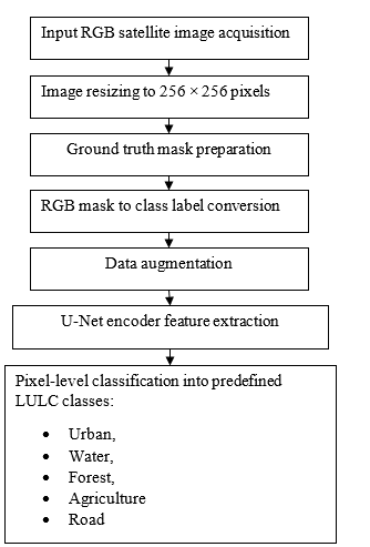
Accurate urban and environmental Land Use/Land Cover (LULC) classification from satellite imagery is essential for sustainable urban planning, environmental monitoring, and resource management. This study presents a high-precision land cover classification framework based on deep image segmentation using a U-Net convolutional neural network architecture. The proposed system processes RGB satellite images resized to a uniform resolution of 256 × 256 pixels to ensure computational efficiency and spatial consistency. Ground truth segmentation masks are converted from RGB format into categorical class labels representing five major land cover types: Urban, Water, Forest, Agriculture, and Road. To enhance model generalization and robustness, extensive data augmentation techniques, including rotation, flipping, and scaling, are applied during training. The core segmentation model employs a four-stage encoder–decoder U-Net architecture that enables hierarchical extraction of spatial and textural features through successive convolution and pooling operations, followed by symmetric upsampling and skip connections for precise boundary localization. This design effectively captures both global contextual information and fine-grained structural details in complex urban and environmental scenes. Experimental results demonstrate that the proposed Deep U-Net–based segmentation approach achieves high classification accuracy and clear class separability across diverse land cover categories. The framework provides a reliable and scalable solution for automated urban and environmental LULC mapping, supporting data-driven decision-making in geospatial analysis, smart city development, and environmental conservation applications.
Keywords: Land Use/Land Cover (LULC) Classification, Satellite Image Segmentation, Deep Learning, U-Net Architecture, Urban and Environmental Mapping
NOTE: Without the concern of our team, please don't submit to the college. This Abstract varies based on student requirements.
Block Diagram
Specifications
Software: Matlab 2022b or above
Hardware:
Operating Systems:
- Windows 10
- Windows 7 Service Pack 1
- Windows Server 2019
- Windows Server 2016
Processors:
Minimum: Any Intel or AMD x86-64 processor
Recommended: Any Intel or AMD x86-64 processor with four logical cores and AVX2 instruction set support
Disk:
Minimum: 2.9 GB of HDD space for MATLAB only, 5-8 GB for a typical installation
Recommended: An SSD is recommended A full installation of all MathWorks products may take up to 29 GB of disk space
RAM:
Minimum: 4 GB
Recommended: 8 GB
Learning Outcomes
· Introduction to Matlab
· What is EISPACK & LINPACK
· How to start with MATLAB
· About Matlab language
· Matlab coding skills
· About tools & libraries
· Application Program Interface in Matlab
· About Matlab desktop
· How to use Matlab editor to create M-Files
· Features of Matlab
· Basics on Matlab
· What is an Image/pixel?
· About image formats
· Introduction to Image Processing
· How digital image is formed
· Importing the image via image acquisition tools
· Analyzing and manipulation of image.
· Phases of image processing:
o Acquisition
o Image enhancement
o Image restoration
o Color image processing
o Image compression
o Morphological processing
o Segmentation etc.,
· How to extend our work to another real time applications
· Project development Skills
o Problem analyzing skills
o Problem solving skills
o Creativity and imaginary skills
o Programming skills
o Deployment
o Testing skills
o Debugging skills
o Project presentation skills
o Thesis writing skills
Demo Video


Request for Video
 Paper Publishing
Request Call Back
Would you like to receive a free callback now?
Choose the best time for callback:
Leave your message and we will contact you as soon as possible

6-2-85/B, Old Maternity Hospital Road, Thyagaraja Nagar, Tirupati, Andhra Pradesh – 517501
+91 9030333433
+91 9393939065
0877-2261612

Disclaimer - Takeoff Edu Group Projects are not associated or affiliated with IEEE in any way. The IEEE Projects mentioned here are mentioned in the context of student projects, whose ideas are derived from IEEE publications, not projects of or by IEEE.