Deep Learning Based Deforestation Classification
Objective
The objective of this project is a crucial research goal, is the use of satellite data for LU/LC (land use, Land change) classification. Forests degradation and deforestation aggravate global warming, and the LULC information found from satellite data is now very essential for global environmental conservation and ecosystem. The major contribution of work is inaugurating the remote sensing techniques in spatiotemporal analysis of land use changes and detecting deforestation, forest degradation, and monitoring forest dynamics in Amazon rainforests.
Abstract
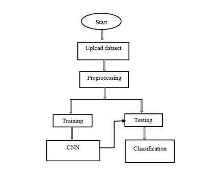
Human-induced deforestation has a major impact on forest ecosystems and therefore its detection and analysis methods should be improved. Where, this type of detection or classification helps us to degrade the deforestations in future. In this project we are mainly focusing on the problem of deforestation, performing the classification of deforestation and the healthy forests with the help of deep learning model. CNN is the algorithm that which are been using here for the classification process. We are preparing a dataset which is trained using the algorithm and classification will be performed in testing.
Keywords: Deforestation, Deep learning, CNN
NOTE: Without the concern of our team, please don't submit to the college. This Abstract varies based on student requirements.
Block Diagram

Specifications
H/W Configuration:
· Processor : I3/Intel Processor
· Hard Disk : 160GB
· RAM : 8Gb
S/W Configuration:
· Operating System : Windows 7/8/10 .
· Server side Script : HTML, CSS & JS.
· IDE : Pycharm.
· Libraries Used : Numpy, IO, OS, Flask, keras.
· Technology : Python 3.6+.
Learning Outcomes
- Practical exposure to
- Hardware and software tools
- Solution providing for real time problems
- Working with team/individual
- Work on creative ideas
- Testing techniques
- Error correction mechanisms
- What type of technology versions is used?
- Working of Tensor Flow
- Implementation of Deep Learning techniques
- Working of CNN algorithm
- Building of model creations
- Scope of project
- Applications of the project
- About Python language
- About Deep Learning Frameworks
- Use of Data Science


 Paper Publishing
