Automated Land Use classification from satellite imageryA Deep learning
Objective
This project presents an automated land use and cover classification system using high-resolution satellite imagery and deep learning. The system employs a U-Net++ model, trained on the DeepGlobe Land Cover Classification Dataset, to classify land into seven categories: urban, agriculture, rangeland, forest, water, barren, and unknown. The U-Net++ architecture with nested skip connections enhances segmentation accuracy by capturing multi-scale features. A web application with user registration and login allows authenticated users to upload satellite images and receive predicted land cover masks, supporting environmental monitoring, urban planning, and sustainable land management.
Abstract
This project introduces an automated land use and land cover classification system based on high-resolution satellite imagery and deep learning. Trained on the DeepGlobe Land Cover Classification Dataset, which consists of paired RGB satellite images and annotated masks, a U-Net++ semantic segmentation model is utilized to classify land into seven categories: urban land (man-made built-up areas), agriculture land (farms and plantations), rangeland (open green areas), forest land (tree-covered regions), water (rivers, lakes, and wetlands), barren land (unvegetated rocky or sandy areas), and unknown. The U-Net++ architecture, featuring nested skip connections, improves segmentation accuracy by effectively capturing multi-scale features in complex landscapes. To make the system accessible, a web application is developed with user registration and login functionality, allowing authenticated users to upload satellite images and receive accurate predicted land cover masks. This tool supports environmental monitoring, urban planning, and sustainable land management applications. (148 words)
Keywords
Land Cover Classification, Satellite Imagery, Deep Learning, U-Net++, Semantic Segmentation, DeepGlobe Dataset, Web Application, Remote Sensing, Land Use Mapping, Convolutional Neural Networks
NOTE: Without the concern of our team, please don't submit to the college. This Abstract varies based on student requirements.
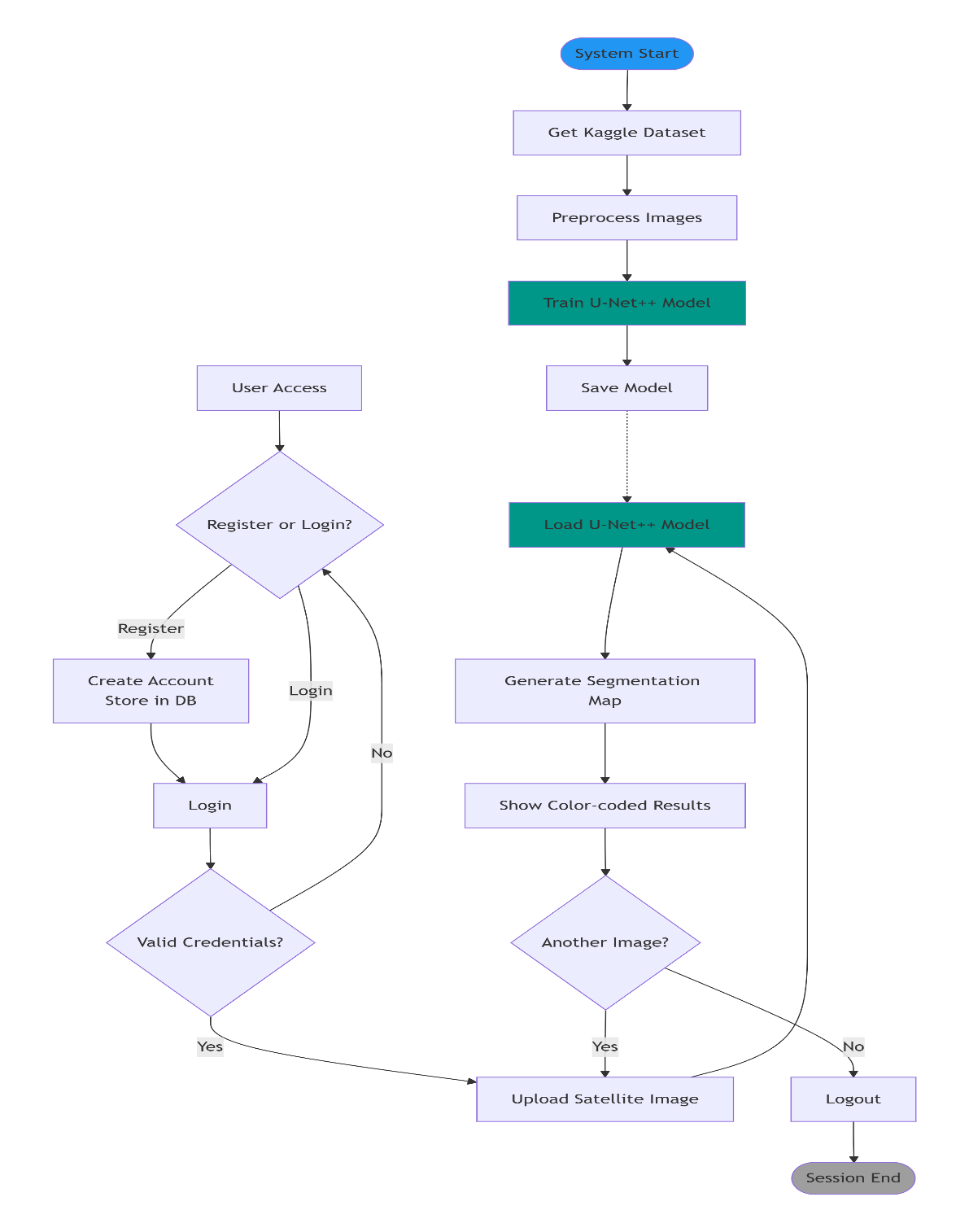
Block Diagram
Specifications
SOFTWARE REQUIREMENS
Operating System : Windows 7/8/10
Server-side Script : HTML, CSS, Bootstrap & JS
Programming Language : Python
Libraries : Flask, Pandas, Sklearn,Pytorch,Torchvision NumPy, Seaborn, Matplotlib,smp,albumentations
IDE/Workbench : VSCode
Technology : Python 3.8+
Server Deployment : Xampp Server
Database : MySQL
HARDWARE REQUIREMENTS
Processor - I5/Intel Processor
RAM - 8GB+ (min)
Hard Disk - 128 GB+
Key Board - Standard Windows Keyboard
Mouse - Two or Three Button Mouse
Monitor - Any


 Paper Publishing

Request Call Back
Would you like to receive a free callback now?
Choose the best time for callback:
Leave your message and we will contact you as soon as possible

6-2-85/B, Old Maternity Hospital Road, Thyagaraja Nagar, Tirupati, Andhra Pradesh – 517501
+91 9030333433
+91 9393939065
0877-2261612

Disclaimer - Takeoff Edu Group Projects are not associated or affiliated with IEEE in any way. The IEEE Projects mentioned here are mentioned in the context of student projects, whose ideas are derived from IEEE publications, not projects of or by IEEE.