Artificial Intelligence Techniques for Landslides Prediction Using Satellite Imagery
Objective
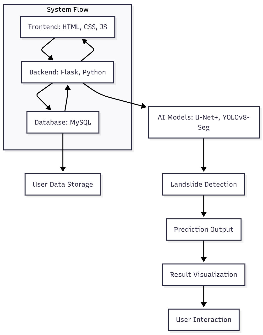
The objective of this project is to develop an AI-based system for accurate landslide prediction using high-resolution satellite imagery. The system employs advanced deep learning techniques, specifically U-Net+ and YOLOv8-Seg, to segment and detect landslides from remote sensing data. By automating the process of landslide detection, the project aims to provide a reliable tool for early warning, risk assessment, and mitigation planning. The goal is to improve the efficiency of identifying landslide-prone areas, enhance disaster preparedness, and support decision-making in regions susceptible to landslides, ultimately reducing the impact on human life and infrastructure.
Abstract
Landslides are among the most devastating natural hazards, causing significant damage to infrastructure, environment, and human lives. Accurate and timely detection of landslide‑prone areas is critical for hazard mitigation, early warning, and disaster management. In this study, we investigate the efficacy of modern deep‑learning segmentation techniques for automated landslide detection from high‑resolution satellite imagery. We utilize the publicly available Bijie Landslide Dataset — a dataset curated for landslide mapping via remote sensing — as well as another annotated collection from Landslide4Sense, for model development and validation.
Leveraging two complementary architectures — a modified U-Net+ (an enhanced U‑Net variant) and YOLOv8-Seg — our pipeline performs pixel-level segmentation to delineate landslide scars and boundaries. The U‑Net+ model captures multi-scale spatial context and refines boundary detection, while YOLOv8‑Seg enables efficient detection and segmentation even in complex terrain with heterogenous textures. We apply standard data preprocessing and augmentation steps — including cropping, normalization, flipping, and rotation — to improve model robustness under varying seasonal, lighting, and topographic conditions.
Experimental results demonstrate that the proposed segmentation models yield high accuracy in landslide delineation. Quantitative evaluation using metrics such as precision, recall, F1‑score, and intersection-over-union (IoU) indicates that U‑Net+ attains strong segmentation performance, while YOLOv8‑Seg shows competitive boundary detection with good generalization across different regions. Comparison with baseline and existing methods suggests that our approach improves both the delineation quality and computational efficiency.
This work highlights the potential of AI‑backed segmentation methods in remote sensing for landslide hazard mapping and risk assessment. The results can support early detection, monitoring, and mitigation strategies — especially in regions prone to landslide disasters. Future work will explore integrating additional spatial data (e.g., DEM, slope, vegetation) and temporal analysis to extend the approach toward predictive landslide susceptibility modelling.
Keywords: Landslide prediction, satellite imagery, deep learning, U-Net+, YOLOv8-Seg, segmentation, remote sensing, hazard mapping, AI techniques, disaster management, spatial data, landslide detection, machine learning, risk assessment, terrain analysis, model evaluation, precision, recall, F1-score, intersection-over-union (IoU).NOTE: Without the concern of our team, please don't submit to the college. This Abstract varies based on student requirements.
Block Diagram
Specifications
SOFTWARE REQUIREMENS
Operating System : Windows 7/8/10
Server side Script : HTML, CSS, Bootstrap & JS
Programming Language : Python
Libraries Flask, Pandas, Torch, Keras, Sklearn,Numpy , Seaborn
IDE/Workbench : VSCode
Server Deployment : Xampp Server
Database : MySQL
HARDWARE REQUIREMENTS
Processor - I3/Intel Processor
RAM - 8GB (min)
Hard Disk - 128 GB
Key Board - Standard Windows Keyboard
Mouse - Two or Three Button Mouse
Monitor - Any

Demo Video


Request for Video
 Paper Publishing
Request Call Back
Would you like to receive a free callback now?
Choose the best time for callback:
Leave your message and we will contact you as soon as possible

6-2-85/B, Old Maternity Hospital Road, Thyagaraja Nagar, Tirupati, Andhra Pradesh – 517501
+91 9030333433
+91 9393939065
0877-2261612

Disclaimer - Takeoff Edu Group Projects are not associated or affiliated with IEEE in any way. The IEEE Projects mentioned here are mentioned in the context of student projects, whose ideas are derived from IEEE publications, not projects of or by IEEE.