Artificial Intelligence Techniques for Landslides Prediction Using Satellite Imagery
Objective
This study aims to develop an accurate landslide prediction system using satellite imagery and a ResNet101 deep learning model to classify regions as landslide-prone or stable for improved environmental risk management.
Abstract
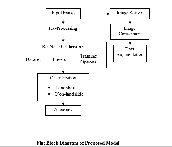
This study presents a comprehensive approach to predicting landslides using artificial intelligence techniques applied to satellite imagery. The process begins with the collection of satellite images, which are resized to a uniform dimension to ensure consistency in analysis. Utilizing a deep learning model, specifically the ResNet101 neural network, the images are subjected to landslide classification. The ResNet101 architecture, known for its robust feature extraction capabilities, enables the model to effectively differentiate between areas prone to landslides and those that are stable. Through the training process, the network learns to identify critical features associated with landslide occurrences, leveraging the vast amount of data available from satellite imagery. The classification task is framed as a binary problem, categorizing each input image as either a "landslide" or "non-landslide." The results of this study underscore the potential of leveraging advanced artificial intelligence techniques in environmental monitoring and disaster risk reduction. By providing accurate and timely predictions of landslide occurrences, this approach can significantly contribute to improved land management practices and enhance the effectiveness of early warning systems, ultimately aiding in mitigating the risks associated with landslides in vulnerable regions.
Index Terms— Landslide classification, satellite image classification, CNN, fuzzy-based classification, Deep Leaning, landslide prediction, landcover classification
NOTE: Without the concern of our team, please don't submit to the college. This Abstract varies based on student requirements.
Block Diagram
Specifications
Software: Matlab 2022b or above
Hardware:
Operating Systems:
- Windows 10
- Windows 7 Service Pack 1
- Windows Server 2019
- Windows Server 2016
Processors:
Minimum: Any Intel or AMD x86-64 processor
Recommended: Any Intel or AMD x86-64 processor with four logical cores and AVX2 instruction set support
Disk:
Minimum: 2.9 GB of HDD space for MATLAB only, 5-8 GB for a typical installation
Recommended: An SSD is recommended A full installation of all MathWorks products may take up to 29 GB of disk space
RAM:
Minimum: 4 GB
Recommended: 8 GB
Learning Outcomes
· Introduction to Matlab
· What is EISPACK & LINPACK
· How to start with MATLAB
· About Matlab language
· Matlab coding skills
· About tools & libraries
· Application Program Interface in Matlab
· About Matlab desktop
· How to use Matlab editor to create M-Files
· Features of Matlab
· Basics on Matlab
· What is an Image/pixel?
· About image formats
· Introduction to Image Processing
· How digital image is formed
· Importing the image via image acquisition tools
· Analyzing and manipulation of image.
· Phases of image processing:
o Acquisition
o Image enhancement
o Image restoration
o Color image processing
o Image compression
o Morphological processing
o Segmentation etc.,
· How to extend our work to another real time applications
· Project development Skills
o Problem analyzing skills
o Problem solving skills
o Creativity and imaginary skills
o Programming skills
o Deployment
o Testing skills
o Debugging skills
o Project presentation skills
o Thesis writing skillsDemo Video


Request for Video
Related Projects
 Paper Publishing
Request Call Back
Would you like to receive a free callback now?
Choose the best time for callback:
Leave your message and we will contact you as soon as possible

6-2-85/B, Old Maternity Hospital Road, Thyagaraja Nagar, Tirupati, Andhra Pradesh – 517501
+91 9030333433
+91 9393939065
0877-2261612

Disclaimer - Takeoff Edu Group Projects are not associated or affiliated with IEEE in any way. The IEEE Projects mentioned here are mentioned in the context of student projects, whose ideas are derived from IEEE publications, not projects of or by IEEE.