Advanced Multi-Scale Vision Transformer with Neural Architecture Search for Thyroid Cancer Diagnosis Using Ultrasound Images
Objective
This project addresses road extraction from very high-resolution satellite images, tackling occlusions, clutter, and thin road shapes. Two segmentation models—DeepAttnLab (with attention mechanisms) and PSPNet (with pyramid pooling)—share a ResNet50 backbone and stride modification to retain spatial detail. A combined BCE, Dice, and Focal loss handles class imbalance. Both models outperform the SDFFNet baseline. The best model is deployed in a Flask web application featuring user login, a relevance classifier to reject non-satellite inputs, and real-time road mask prediction, achieving accurate and continuous road extraction.
Abstract
Thyroid
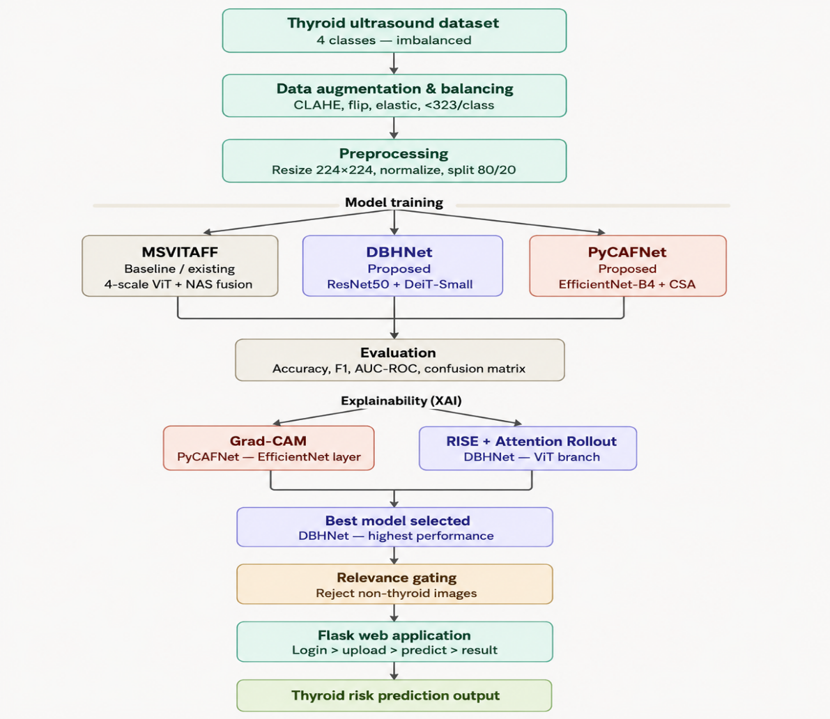
cancer diagnosis from ultrasound images requires accurate classification into
four risk categories: Not Suspicious, Mildly Suspicious, Moderately Suspicious,
and Highly Suspicious. The task is challenging due to subtle visual differences
between classes and severe data imbalance. This work proposes two novel deep
learning architectures for automated thyroid cancer risk stratification. DBHNet
is a dual‑branch hybrid network that combines a ResNet50 branch for local
texture extraction and a DeiT‑Small transformer branch for global contextual
reasoning, fused through learnable weighted concatenation. PyCAFNet is a
pyramid cross‑scale attention network built on an EfficientNet‑B4 backbone,
incorporating sequential cross‑scale attention modules and a NAS‑inspired
weighted multi‑scale fusion head. Both models are benchmarked against MSViTAFF,
an existing multi‑scale Vision Transformer baseline. Class imbalance is
addressed using an augmentation pipeline that includes CLAHE, elastic
transforms, and geometric augmentations. Explainability is embedded through
Grad‑CAM for PyCAFNet and RISE combined with attention rollout for DBHNet,
providing clinically interpretable heatmap visualizations. DBHNet is deployed
in a Flask‑based web application with relevance gating to reject non‑thyroid
inputs, enabling rapid risk prediction.
Keywords: Thyroid cancer diagnosis · Ultrasound image classification · Dual-branch hybrid network · Pyramid cross-scale attention · Neural architecture search · Explainable AI (XAI) · RISE · Attention Rollout · Grad-CAM · Flask deployment
NOTE: Without the concern of our team, please don't submit to the college. This Abstract varies based on student requirements.
Block Diagram
Specifications
.2 SOFTWARE REQUIREMENS
Operating System : Windows 7/8/10
Server-side Script : HTML, CSS, Bootstrap & JS
Programming Language : Python
Libraries : Flask, Pandas, Pytorch,Torchvision NumPy, Seaborn, Matplotlib, pillow, Cv2
IDE/Workbench : VSCode
Technology : Python 3.10+
Server Deployment : Xampp Server
Database : MySQL
4.3 HARDWARE REQUIREMENTS
Processor - I5/Intel Processor
RAM - 8GB +(min)
Hard Disk - 128 +GB
Key Board - Standard Windows Keyboard
Mouse - Two or Three Button Mouse
Monitor - Any


 Paper Publishing

Request Call Back
Would you like to receive a free callback now?
Choose the best time for callback:
Leave your message and we will contact you as soon as possible

6-2-85/B, Old Maternity Hospital Road, Thyagaraja Nagar, Tirupati, Andhra Pradesh – 517501
+91 9030333433
+91 9393939065
0877-2261612

Disclaimer - Takeoff Edu Group Projects are not associated or affiliated with IEEE in any way. The IEEE Projects mentioned here are mentioned in the context of student projects, whose ideas are derived from IEEE publications, not projects of or by IEEE.