A Novel Design Approach to Implement Software Ecosystems for Territorial Monitoring
Objective
The objective of this project is to develop an open-source software ecosystem (SECO) for effective territorial monitoring, leveraging the integration of diverse data sources, including satellite imagery and ground-based sensors. The system aims to create a unified data stream that supports real-time analysis of environmental parameters such as air quality, temperature, and walkability, which are key indicators of Quality of Life (QoL) in urban settings. Through the application of machine learning algorithms like Random Forest, Adaboost, GradientBoosting, and XGBoost, the project seeks to enhance urban planning, sustainability efforts, and improve decision-making for territorial management and environmental monitoring.
Abstract
This research proposes a novel design approach for the creation of open-source software ecosystems (SECO) specifically for territorial monitoring. The primary aim is to integrate a wide array of data sources, including satellite imagery and ground-based sensors, to build a cohesive and adaptable system for monitoring various environmental factors. The core of this approach lies in the semantic integration of these diverse data streams to create a unified model that can be used for real-time territorial analysis. A use case is explored where air quality, temperature, and walkability indices are evaluated as key indicators of Quality of Life (QoL) in urban areas. The research leverages multiple machine learning algorithms, including Random Forest, Adaboost, GradientBoosting, and XGBoost, to process and analyze the collected data. The datasets used for this study include air quality data from India, weather data, and urban sustainability metrics. This integrated approach aims to provide valuable insights into urban planning, sustainability, and environmental monitoring, offering a scalable framework for future territorial monitoring systems.
Keywords: Open-Source Software Ecosystems (SECO), Territorial Monitoring, Semantic Integration, Satellite Imagery, Ground-Based Sensors, Air Quality, Temperature Monitoring, Walkability, Quality of Life (QoL), Machine Learning Algorithms, Random Forest, Adaboost, GradientBoosting, XGBoost, Urban Sustainability, Environmental Data Analysis, Urban Planning, Data Integration.
NOTE: Without the concern of our team, please don't submit to the college. This Abstract varies based on student requirements.
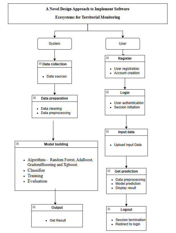
Block Diagram
Specifications
Hardware Requirements
Processor - I3/Intel Processor
Hard Disk - 160GB
Key Board - Standard Windows Keyboard
Mouse - Two or Three Button Mouse
Monitor - SVGA
RAM - 8GB
Software Requirements:
Operating System : Windows 7/8/10
Server side Script : HTML, CSS, Bootstrap & JS
Programming Language : Python
Libraries : Django, Pandas, Numpy, Tensorflow, Scikit-learn.
IDE/Workbench : VS Code
Technology : Python 3.10
Database : SQLite


 Paper Publishing

Request Call Back
Would you like to receive a free callback now?
Choose the best time for callback:
Leave your message and we will contact you as soon as possible

6-2-85/B, Old Maternity Hospital Road, Thyagaraja Nagar, Tirupati, Andhra Pradesh – 517501
+91 9030333433
+91 9393939065
0877-2261612

Disclaimer - Takeoff Edu Group Projects are not associated or affiliated with IEEE in any way. The IEEE Projects mentioned here are mentioned in the context of student projects, whose ideas are derived from IEEE publications, not projects of or by IEEE.