Satellite Image Classification Method Using ELBP and SVM Classifier
Also Available Domains Deep Learning
Objective
In this project a convolutional neural network for automated wildfire detection on high-resolution aerial photos is presented.
Abstract
For the classification of satellite images into 24 separate classes, machine learning-based Support vector machine (SVM) and Extended Local Binary Patterns (ELBP) algorithms were applied. This work is capable of classifying 24 different classes in addition to satellite images. However, identifying the features of those other classes, such as the human face, football and rugby is also simple because these other classes have some unique features that can be easily distinguished, allowing for easy classification.
The fundamental challenge in the case of satellite photos is that distinct satellite images may have different attributes, making satellite image classification difficult. Another difficulty is that most satellite photos are noise-corrupted. The SVM Classifier is used to estimate the noise patterns in the wireless image, and the estimated noise patterns are then removed using the SVM signal classification technique.
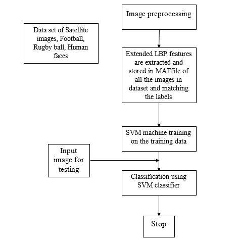
Using the proposed ELBP approach, this research discovers local binary patterns. Because the patterns of distinct satellite photos and other class images cannot be distinguished using simply LBP, the Extended LBP is required. SVM identifies the test image's class based on the expanded features gathered. The ELBP-SVM approach was applied in this study, and the satellite picture correct recognition rate was 95 percent. The results produced using MATLAB 2020a are superior than those obtained using other methods to classify satellite photos.
Keywords: Local binary patterns, Support vector machine, Satellite imagery, Machine learning, Feature extraction.
NOTE: Without the concern of our team, please don't submit to the college. This Abstract varies based on student requirements.
Block Diagram

Specifications
Software & Hardware Requirements:
Software: Matlab 2020a or above
Hardware:
Operating Systems:
- Windows 10
- Windows 7 Service Pack 1
- Windows Server 2019
- Windows Server 2016
Processors:
- Minimum: Any Intel or AMD x86-64 processor
- Recommended: Any Intel or AMD x86-64 processor with four logical cores and AVX2 instruction set support
Disk:
- Minimum: 2.9 GB of HDD space for MATLAB only, 5-8 GB for a typical installation
- Recommended: An SSD is recommended A full installation of all MathWorks products may take up to 29 GB of disk space
RAM:
- Minimum: 4 GB
- Recommended: 8 GB
Learning Outcomes
- Introduction to Matlab
- How to start with MATLAB
- About Matlab language
- Matlab coding skills
- About tools & libraries
- Application Program Interface in Matlab
- About Matlab desktop
- How to use Matlab editor to create M-Files
- Features of Matlab
- Basics on Matlab
- What is an Image/pixel?
- About image formats
- Introduction to Image Processing
- How digital image is formed
- Importing the image via image acquisition tools
- Analyzing and manipulation of image.
- Phases of image processing:
- Acquisition
- Image enhancement
- Image restoration
- Color image processing
- Image compression
- Morphological processing
- Segmentation etc.,
- How to extend our work to another real time applications
- Project development Skills
- Problem analyzing skills
- Problem solving skills
- Creativity and imaginary skills
- Programming skills
- Deployment
- Testing skills
- Debugging skills
- Project presentation skills
- Thesis writing skills


 Paper Publishing
