An Aerial Image Segmentation Approach Based on Enhanced Multi-scale Convolutional Neural Network
Abstract
In this work, we proposed a novel aerial image segmentation method based on Convolutional Neural Network (CNN). Aerial images are the images captured from high attitudes above the ground. Processing and analyzing aerial images play central roles in terrain modeling, agricultural monitoring, city planning, environmental surveillance, etc. Aerial images are developing towards high resolution and large size, which poses a major challenge in pixel-level image segmentation.
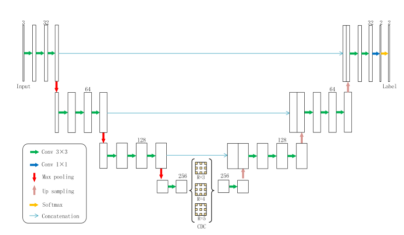
With the rapid development of deep learning technology, the application of deep learning to image semantic segmentation has obtained satisfactory effect. The main structure of the proposed network adopts U-Net. In order to capture objects of different scales in the deep features, a group of cascaded dilated convolution is inserted at the bottom of U-Net which has different dilation rates. Furthermore, to better optimize the network at different scales, an auxiliary loss function is proposed to be integrated in the cascaded dilated convolution. The effectiveness of the proposed method is evaluated on the Inria Aerial Image Labeling Data set. Experiment results show that the proposed method has better segmentation performance than existing approaches.
NOTE: Without the concern of our team, please don't submit to the college. This Abstract varies based on student requirements.
Block Diagram
Specifications

Contact Us
- info@takeoffprojects.com
- +91 9030333433, +91 9393939065


 Paper Publishing

Request Call Back
Would you like to receive a free callback now?
Choose the best time for callback:
Leave your message and we will contact you as soon as possible

1st Floor, 1-5-558, 2nd St, Balaji Colony, Tirupati, Andhra Pradesh 517502.
+91 9030333433
+91 8776681444
+91 9393939065

Disclaimer - Takeoff Edu Group Projects are not associated or affiliated with IEEE in any way. The IEEE Projects mentioned here are mentioned in the context of student projects, whose ideas are derived from IEEE publications, not projects of or by IEEE.
